Up at 6AM and off by 8AM. We left the Skyline Drive to head for Harrisonburg VA and the chance to resupply for the next few days on the Blue Ridge Parkway and at Great Smoky Mountain National Park.
To cover distance quickly, we stayed off the beautiful, 35-mph Skyline Drive and Blue Ridge Parkway, and entered North Carolina on Interstate 81
We returned to the Blue Ridge Parkway near Boone NC to enjoy the scenery
The Moses Cone Visitors Center was run by the National Park Service and it included a shop that sold local crafts.
Our camp site was comfortable enough but without the showers or even hot water we've enjoyed at previous US Park Service camp grounds.
Still, with our federal seniors park passes it was only $8 per night -- versus $16 for those without a pass. These passes are available to any US resident or citizen aged 62 or over. At $10, they are one of the the all time bargins, giving us free access or 50% discounts at US parks, national forests, national monuments and many other federal facilities. Unfortunately, they don't apply to state parks.
Day 9 - 7 June 2015 [110 miles from Julian Price to Mt Pisgah]
We broke camp in the rain. A heavy mist continued throughout the morning. At times we were travelling at 20 mph through the fog. We stopped at the Linn Cove Viaduct, the last part of the Blue Ridge Parkway to be finished in the 1980's. The visitor center had nice displays about the viaduct and Grandfather Mountain, but it was too foggy to get any photos of the real thing. The viaduct is raised above the rocky surface as it goes over a difficult and ecologically sensitive section of the mountain.
We stopped to walk to Linville Falls. The walk went through nice forest
and the falls though pleasant were not remarkable. Linville Gorge, downstream, is one of only 2 designated wilderness areas in the eastern U.S.
A poster at the visitor center indicated the local importance of the Parkway, reflected the large volume of motorcycle traffic on the Parkway and revealed a certain irreverence in the otherwise conservative psyche of Southern officialdom.
Catawba rhododendrons are common all along the Parkway, but were particularly common and beautiful at Craggy Gardens
as were the wild azaleas
We stayed on the Parkway most of the day, but exited to see Asheville. The Grove Arcade has provided a focus for downtown Asheville. It and the surrounding blocks have small shops and a vibrant café culture.
The Arcade was taken over by the US government during WWII, and only returned to civilian use in the 1990's after being petitioned by local citizens.
Our last stop en route was the Folk Art Center http://www.southernhighlandguild.org/pages/folk-art-center/general-info.php
The Center is a comercial outlet for local artisans, a museum, a research institution and a collective. A display by local crafts students was particularly impressive.
We're getting used to setting up camp in a new spot each night (or two). The Mt Pisgah campground is particularly nice, with hot water and hot showers. The sights are spacious and nicely landscaped. Our 8 ft by 8 ft tent is a comfortable 'home' and a great shelter from the rains we've had over the past few nights.
Day 10 - 8 June 2015 [Mount Pisgah to Smokemont, Smoky Mountains NP, 91 miles]
Another deluge and thunderstorm last night, but the tent remained dry and we awoke to sunshine. The tent sites at the NP campgrounds have large, square 'sand boxes' filled with crushed gravel and sand. These are flat, take tent stakes easily, and most importantly drain water quickly.
We hiked the 1.7 mile trail to the top of Mt Pisgah. Well, more like 2.3 miles, because we didn't find the right parking lot. The track was lined with more rhododendrons and laurel. The laurel varied in color from white to bright pink
A large communications tower on the summit obscured views to the North,
but otherwise we could see nearly 360 degrees views from a platform at the top.
Our 1-PM lunch stop on the Parkway included views of this rock dome -- with the effects of natural terpenes, water vapor and air pollution showing in the more distant 'smoky' mountains.
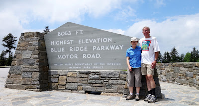
We reached the highest point on the Parkway and then began the descent to Cherokee NC.
The park visitor center has displays about the farms that were within the park at the time it was established.
It takes about 10 gallons of sorghum sap to make a gallon of sorghum molasses, whereas it takes about four times as much maple sap to make a gallon of maple syrup. The sap is concentrated by running it through an evaporator over a wood fire. The evaporator consists of a maze of channels. Sap is poured into one end and molasses removed from the other. It's quite similar to the process of making maple syrup.
Near the visitor center is Mingus Mill, a grain mill water powered by a water turbine rather than a water wheel.
The day we visited, they were making corn meal.
Stream that parallelled the road into the park from the Cherokee side.
We walked up to the Chimney Tops lookout from a parking lot 7 miles past Newfound Gap on the Gatlinburg side. Near the beginning there was a beautiful eastern black swallowtail butterfly in the sun in the middle of the track.
The last hundred feet to the top required some rock scrambling.
There were so many people picnicing on the rocks that we decided not to try picking a route through to the very top.
We went back to Newfound Gap and drove the 7 miles SW to Clingman's Dome. The last half mile was a walk to a viewing platform on the summit.
Several species of trees are being attacked by introduced pests. To slow the spread of disease, campers are not allowed to use firewood sourced from outside the park. Around Clingman's Dome adelgids have attacked the balsam firs leaving white skeletons standing in the forest.We drove over Newfound Gap for the second time and continued on to Cades Cove. The Cove was a farming center at the time the park was formed in the 1930's. The historic sites are accessed from an 11-mile, one-way road starting near the campground. The original fields are maintained, largely through controlled burns each year.
Many of the farm buildings and churches have been preserved or restored.
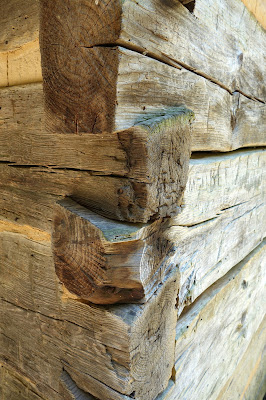
The outside walls were formed from interlocking logs, each one helping to secure the logs above and below it and at 90 degrees to it.
Dried mud sealed the cracks between the logs.
Can you help us to identify the plant with these interesting flowers? It was along the track to the waterfall.
.oOo.


Love reading about your adventures, what a beautiful area, no wonder you want to linger.
ReplyDelete